CATCH BASIN: Know here these are located Using Elevation Maps

LOCATION IS MORE IMPORTANT THAN THE PROPERTY AND PROMOS
As sellers, as much as we want to sell more and earn more, we must also take into consideration the value we provide our clients. They are not only buying the property but also the location, living experience and of course, the future memories they are going to accumulate over time.
Due to the parade of storm that recently devastated parts of Bicol, Calabarzon, Central Luzon and Cagayan Region, property buyers have become more vigilant in looking for a good location.
In the previous article posted by Mr. Lubar, it shows what are the questions that the buyer and seller must take into consideration before buying or selling the property:
-
Is it flood free?
-
Is it away from active fault lines?
-
Is there a low probability of storm surge or tsunami alerts?
-
Is it away from any active volcanoes?
And many more. As you can observe, all of the questions above are related to the geographical location of the property. However, there’s no such place in Metro Manila that meets all of these requirements. There will always be one criteria that is not satisfied.
For example, Manila, Pasay, Las Piñas, Valenzuela and Navotas are away from fault lines and active volcanoes but it is prone to tsunami and flooding. Muntinlupa, Pasig, Northern Quezon City, Taguig, Pateros and North Caloocan is away from any tsunami warnings but it is located in West Valley Fault. Marikina is a more devastated area, there might be no tsunami warnings but risk of flooding and earthquake is still there.
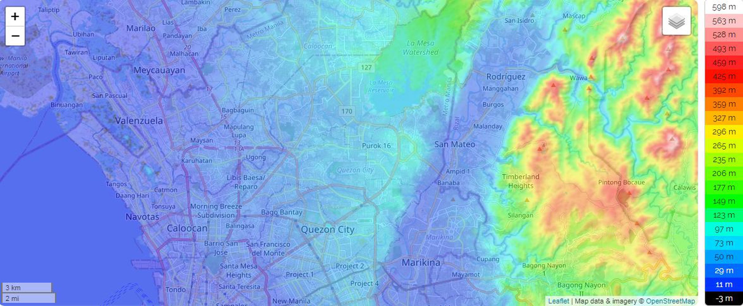
In order for us to check the location if it’s a catch basin on floods or not, we can check its elevation relative to sea level. As you can see in the picture, this only shows why there’s a huge chance of flooding in Rodriguez, Rizal and Marikina due to its elevation relative to Quezon City and Rizal Province. Note that some areas of Navotas and Pasay are 3 to 5 meters BELOW SEA LEVEL especially the area of MALL OF ASIA (MOA) COMPLEX.
This map is a very informative and enjoyable to observe because you can learn more about the area without needing to actually live there.

BUT, there’s a way to still sell these properties to the market even if these are located in a flood-prone or earthquake-prone areas. We must need to check the following:
-
Is the project elevated relative to the public areas?
-
Is the project sustainable of providing electricity during the hard times of strong typhoons?
-
Can the building support at least Magnitude 8 earthquake without leaving any severe damages?
-
What materials were used in constructing the building that supports the idea that it can withstand a strong earthquake.
-
For condo development, is there a reasonable explanation showing the emergency routes and plans in case of severe disaster? Are there ample amount of fire exits to accommodate all unit owners?
And many more to know about the project. It is very hard for a buyer to lose his investments in this kind of time… But it is harder for them to lose their love ones because they are not fully aware on what they just bought from us…
CHECK YOUR LOCATION OR YOUR PROJECT’S LOCATION TO KNOW IF IT’S ELEVATED OR NOT
VISIT: https://en-nz.topographic-map.com/maps/nlnk/Metro-Manila/
0 Likes0 Replies-
METRO PRIMO | Properties for Sale by Carlo Manalo